Papua New Guinea - MC Grecof


Main menu:


Papua New Guinea
Introduction |
|||
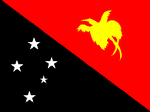
Flag: |
|
||
Card: |
|
||
Background: |
The eastern half of the island of New Guinea - second largest in the world - was divided between Germany (north) and the UK (south) in 1885. The latter area was transferred to Australia in 1902, which occupied the northern portion during World War I and continued to administer the combined areas until independence in 1975. A nine-year secessionist revolt on the island of Bougainville ended in 1997, after claiming some 20,000 lives. |
||
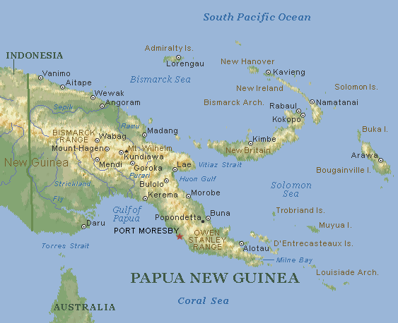
Geography |
|||
Location: |
Southeastern Asia, group of islands including the eastern half of the island of New Guinea between the Coral Sea and the South Pacific Ocean, east of Indonesia |
||
Coordinates: |
6° 00' S, 147° 00' E |
||
Map references: |
Oceania |
||
Area: |
total: 462,840 sq km |
||
Land boundaries: |
border countries: Indonesia 820 km |
||
Coastline: |
5.152 km |
||
Climate: |
mostly mountains with coastal lowlands and rolling foothills |
||
Terrain: |
mostly mountains with coastal lowlands and rolling foothills |
||
Elevation extremes: |
lowest point: Pacific Ocean 0 m |
||
Geography - note: |
shares island of New Guinea with Indonesia; one of world's largest swamps along southwest coast |
||
People |
|||
Population: |
5.049.055 (July 2001 est.) |
||
Nationality: |
noun: Papua New Guinean(s) |
||
Ethnic groups: |
Melanesian, Papuan, Negrito, Micronesian, Polynesian |
||
Religions: |
Roman Catholic 22%, Lutheran 16%, Presbyterian/Methodist/London Missionary Society 8%, Anglican 5%, Evangelical Alliance 4%, Seventh-Day Adventist 1%, other Protestant 10%, indigenous beliefs 34% |
||
Languages: |
English spoken by 1%-2%, pidgin English widespread, Motu spoken in Papua region |
||
Flag description: |
divided diagonally from upper hoist-side corner; the upper triangle is red with a soaring yellow bird of paradise centered; the lower triangle is black with five, white, five-pointed stars of the Southern Cross constellation centered |
||
Economy |
|||
Economy - overview: |
Papua New Guinea is richly endowed with natural resources, but exploitation has been hampered by the rugged terrain and the high cost of developing infrastructure. Agriculture provides a subsistence livelihood for 85% of the population. Mineral deposits, including oil, copper, and gold, account for 72% of export earnings. The 3.4% average annual growth rate of GDP during 1979-1998 conceals considerable year-to-year variation resulting from external economic shocks, natural disasters, and economic management problems. There has been little growth in the last half of the 1990s, with real GDP in 1999 barely 3% higher than in 1994, not enough to compensate for population growth. A new administration under the leadership of Prime Minister Mekere MORAUTA in July 1999 has promised to restore integrity to state institutions, to stabilize the kina, to restore stability to the national budget, to privatize public enterprises where appropriate, and to ensure ongoing peace on Bougainville. The government has had considerable success in attracting international support, specifically gaining the support of the IMF and the World Bank in securing development assistance loans. Significant challenges remain for MORAUTA, however, including gaining further investor confidence, specifically for the proposed Papua New Guinea-Australia oil pipeline, continuing efforts to privatize government assets, and in maintaining the support from members of Parliament who after 15 July 2001 can dismiss him with a vote of no-confidence. |
||
Industries: |
copra crushing, palm oil processing, plywood production, wood chip production; mining of gold, silver, and copper; crude oil production; construction, tourism |
||
Agriculture - products: |
Coffee, cocoa, coconuts, palm kernels, tea, rubber, sweet potatoes, fruit, vegetables; poultry, pork |
||
Currency: |
kina (PGK) |
||
Currency code: |
PGK |
||
Transportation |
|||
Geleise: |
0 km |
||
Highways: |
total: 19,600 km |
||
Waterways: |
10.940 km |
||
Ports and harbors: |
Kieta, Lae, Madang, PortMoresby, Rabaul |
||
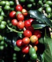
Coffee |
|||
|
|||
Growing-areas: |
Arabicas: |
Goroka, Mount Hagen, Kundiawa |
|
Qualities: |
Arabicas: |
washed and natural (native) classified by defects and size |
|
Altitude: |
Arabicas: |
1.000 to 2.100 meter |
|
Harvest: |
April/September |
||
Shippingperiod: |
June to November |
||
Port of Export: |
Lae (Arabicas) |
||
Shipment: |
in container in bags (300 of each 60.- kos net) |
||
Production: |
1,147,000 bags |
||
Exportabbildungen: |
580,173 bags |
||
Caffeine content: |
1,30 % |
||