Mexico - MC Grecof


Main menu:


Mexico
Introduction |
||||||||||
Flag: |
|
|||||||||
Card: |
|
|||||||||
Background: |
The site of advanced Amerindian civilizations, Mexico came under Spanish rule for three centuries before achieving independence early in the 19th century. A devaluation of the peso in late 1994 threw Mexico into economic turmoil, triggering the worst recession in over half a century. The nation continues to make an impressive recovery. Ongoing economic and social concerns include low real wages, underemployment for a large segment of the population, inequitable income distribution, and few advancement opportunities for the largely Amerindian population in the impoverished southern states. |
|||||||||
Geography |
||||||||||
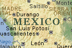
Location: |
Middle America, bordering the Caribbean Sea and the Gulf of Mexico, between Belize and the US and bordering the North Pacific Ocean, between Guatemala and the US |
|||||||||
Geographic coordinates: |
23 00 N, 102 00 W |
|||||||||
Map references: |
North America |
|||||||||
Area: |
total: 1,972,550 sq km |
|||||||||
Coastline: |
9,330 km |
|||||||||
Climate: |
varies from tropical to desert |
|||||||||
Terrain: |
high, rugged mountains; low coastal plains; high plateaus; desert |
|||||||||
Elevation extremes: |
lowest point: Laguna Salada -10 m |
|||||||||
Geography - note: |
strategic location on southern border of US |
|||||||||
People |
||||||||||
Population: |
101,879,171 (July 2001 est.) |
|||||||||
Nationality: |
noun: Mexican(s) |
|||||||||
Ethnic groups: |
mestizo (Amerindian-Spanish) 60%, Amerindian or predominantly Amerindian 30%, white 9%, other 1% |
|||||||||
Religions: |
nominally Roman Catholic 89%, Protestant 6%, other 5% |
|||||||||
Languages: |
Spanish, various Mayan, Nahuatl, and other regional indigenous languages |
|||||||||
Government |
||||||||||
Country name: |
conventional long form: United Mexican States |
|||||||||
Government type: |
federal republic |
|||||||||
Capital: |
Mexico |
|||||||||
Administrative divisions: |
31 states (estados, singular - estado) and 1 federal district* (distrito federal); Aguascalientes, Baja California, Baja California Sur, Campeche, Chiapas, Chihuahua, Coahuila de Zaragoza, Colima, Distrito Federal*, Durango, Guanajuato, Guerrero, Hidalgo, Jalisco, Mexico, Michoacan de Ocampo, Morelos, Nayarit, Nuevo Leon, Oaxaca, Puebla, Queretaro de Arteaga, Quintana Roo, San Luis Potosi, Sinaloa, Sonora, Tabasco, Tamaulipas, Tlaxcala, Veracruz-Llave, Yucatan, Zacatecas |
|||||||||
Independence: |
16 September 1810 (from Spain) |
|||||||||
National holiday: |
Independence Day, 16 September (1810) |
|||||||||
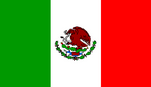
Flag description: |
three equal vertical bands of green (hoist side), white, and red; the coat of arms (an eagle perched on a cactus with a snake in its beak) is centered in the white band |
|||||||||
Economy |
||||||||||
Economy - overview: |
Mexico has a free market economy with a mixture of modern and outmoded industry and agriculture, increasingly dominated by the private sector. The number of state-owned enterprises in Mexico has fallen from more than 1,000 in 1982 to fewer than 200 in 2000. The ZEDILLO administration privatized and expanded competition in seaports, railroads, telecommunications, electricity, natural gas distribution, and airports. A strong export sector helped to cushion the economy's decline in 1995 and led the recovery in 1996-2000. Private consumption became the leading driver of growth in 2000, accompanied by increased employment and higher real wages. Mexico still needs to overcome many structural problems as it strives to modernize its economy and raise living standards. Income distribution is very unequal, with the top 20% of income earners accounting for 55% of income. Trade with the US and Canada has tripled since NAFTA was implemented in 1994. Mexico completed free trade agreements with the EU, Israel, El Salvador, Honduras, and Guatemala in 2000, and is pursuing additional trade agreements with countries in Latin America and Asia to lessen its dependence on the US. |
|||||||||
Industries: |
food and beverages, tobacco, chemicals, iron and steel, petroleum, mining, textiles, clothing, motor vehicles, consumer durables, tourism |
|||||||||
Agriculture - products: |
corn, wheat, soybeans, rice, beans, cotton, coffee, fruit, tomatoes; beef, poultry, dairy products; wood products |
|||||||||
Currency: |
Mexican peso |
|||||||||
Currency code: |
MXN |
|||||||||
Transportation |
||||||||||
Railways: |
total: 31,048 km |
|||||||||
Coffee |
||||||||||
International Organizations: |
Member of the I.C.O. - "Other Milds"group - Code No 16 . |
|||||||||
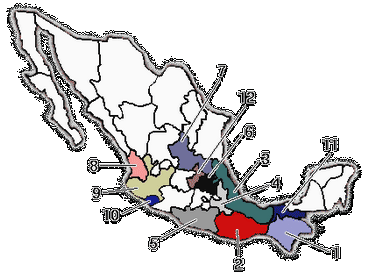
Cultivated Area: |
744,500 hectares divided among 4,300 communities in 381 communes in 12 states. |
|||||||||
Number of Productive Trees: |
538 million coffee trees. |
|||||||||
Yield: |
594 kg per hectare. |
|||||||||
Population Dependent Upon Coffee for Survival : |
3 million. |
|||||||||
Importance of Coffee: |
First agricultural commodity for export. |
|||||||||
Altitude: |
From 400 to 1,700 meters. |
|||||||||
Flowering: |
Low altitudes : from the end of January. |
|||||||||
Harvest: |
Low altitudes : August/November. |
|||||||||
First Shipment: |
November. |
|||||||||
Regions of Production: |
Regions |
States |
Brand Names |
|||||||
Guatemala Border |
Chiapas |
Tapachula, Huixtla |
||||||||
East Tlapacoyan |
Veracruz |
Coatepec, Cordoba, Jalapa, Huatusco |
||||||||
Southwest |
Oaxaca |
Oaxaca, Pluma |
||||||||
Eastern Center |
Puebla |
|||||||||
Southwest |
Gerrero |
|||||||||
Northeast |
Hidalgo |
|||||||||
North |
San Luis-Luis-Potosi |
|||||||||
Northest |
Nayarit |
|||||||||
West |
Jalisco |
|||||||||
Southwest |
Tabasco |
|||||||||
West |
Colima |
|||||||||
West |
Michoacan |
|||||||||
Center |
Cuetzalan |
|||||||||
Period of Exportation: |
Nearly all year but mainly from December to May. |
|||||||||
Preperation: |
Wet method : 90 % - 1,200 processing plants. |
|||||||||
Drying: |
In the sun as well as in dryers. |
|||||||||
Sorting: |
Machine-cleaning - Hand-picking - Electronic sorting. |
|||||||||
Classification: |
Maragogype. |
|||||||||
Strictly High Grown (estrictamento altura) 1,700 meters. |
||||||||||
High Grown (altura) 100/1,600 meters. |
||||||||||
Prime Washed (prima lavado) 700/1,000 meters. |
||||||||||
Good Washed (buena lavado) |
||||||||||
Description: |
Prime Washed |
|||||||||
Caffeine Content: |
flat beans 1.17%. |
|||||||||
Weight of Bags: |
69 kg net. |
|||||||||
Packing: |
Sisal - Mexico is the country which uses the best packing materials in terms of strength and design. |
|||||||||
Production: |
4,577,000 bags - 60 kg base. |
|||||||||
Local Consumption: |
1,700,000 bags - 1.2 kg per capita. |
|||||||||
Exportation: |
Green coffee : 3.2 million bags, of which 88 % go to the U.S.A. |
|||||||||
Organic Coffee: |
It is possible to obtain coffee grown in biologically pure conditions, but there is a high premium. |
|||||||||
Exporters: |
400 privates firms of which a dozen are active. |
|||||||||
Borders Posts: |
Northwest: |
Mexicali 0.8 % Exported by land |
||||||||
Northeast: |
Nuevo Laredo : 64.8 % roasted, instant. |
|||||||||
Ports of Exportation: |
Atlantic: |
Pazific: |
||||||||
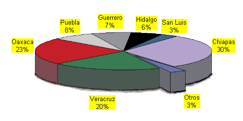
1. - Chiapas |
|
7. - San Luis Potosí |
||||||||
|
||||||||||
TYPE |
EXPORTS |
|||||||||
GREEN COFFEE |
Prime Washed |
2,741,461 |
||||||||
INDUSTRY |
Soluble |
217,115 |
||||||||
OTHERS |
DECAFFEINATED (Included all the Types and Qualities) |
310,544 |
||||||||