Haitii - MC Grecof


Main menu:


Haitii
Introduction |
||
Flag: |
|
|
Card: |
|
|
Background: |
One of the poorest countries in the Western Hemisphere, Haiti has been plagued by political violence for most of its history. Over three decades of dictatorship followed by military rule ended in 1990 when Jean-Bertrand ARISTIDE was elected president. Most of his term was usurped by a military takeover, but he was able to return to office in 1994 and oversee the installation of a close associate to the presidency in 1996. ARISTIDE won a second term as president in 2000, and took office early the following year. |
|
Geography |
||
Location: |
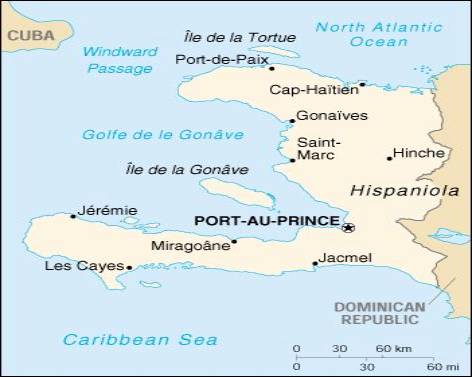
Caribbean, western one-third of the island of Hispaniola, between the Caribbean Sea and the North Atlantic Ocean, west of the Dominican Republic |
|
Geographic coordinates: |
19 00 N, 72 25 W |
|
Map references: |
Central America and the Caribbean |
|
Area: |
total: 27,750 sq km |
|
Land boundaries: |
total: 275 km |
|
Coastline: |
1,771 km |
|
Maritime claims: |
contiguous zone: 24 NM |
|
Climate: |
tropical; semiarid where mountains in east cut off trade winds |
|
Terrain: |
mostly rough and mountainous |
|
Elevation extremes: |
lowest point: Caribbean Sea 0 m |
|
Geography - note: |
shares island of Hispaniola with Dominican Republic (western one-third is Haiti, eastern two-thirds is the Dominican Republic) |
|
People |
||
Population: |
6,964,549 |
|
Nationality: |
noun: Haitian(s) |
|
Ethnic groups: |
black 95%, mulatto and white 5% |
|
Religions: |
Roman Catholic 80%, Protestant 16% (Baptist 10%, Pentecostal 4%, Adventist 1%, other 1%), none 1%, other 3% (1982) |
|
Languages: |
French (official), Creole (official) |
|
Government |
||
Country name: |
conventional short form: Hait |
|
Government type: |
elected government |
|
Capital: |
Port-au-Prince |
|
National holiday: |
Independence Day, 1 January (1804) |
|
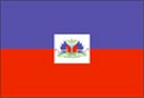
Flag description: |
two equal horizontal bands of blue (top) and red with a centered white rectangle bearing the coat of arms, which contains a palm tree flanked by flags and two cannons above a scroll bearing the motto L'UNION FAIT LA FORCE (Union Makes Strength) |
|
Economy |
||
Economy - overview: |
About 80% of the population lives in abject poverty. Nearly 70% of all Haitians depend on the agriculture sector, which consists mainly of small-scale subsistence farming and employs about two-thirds of the economically active work force. The country has experienced little job creation since the former President PREVAL took office in February 1996, although the informal economy is growing. Following legislative elections in May 2000, fraught with irregularities, international donors - including the US and EU - suspended almost all aid to Haiti. This destabilized the Haitian currency, the gourde, and, combined with a 40% fuel price hike in September, caused widespread price increases. Prices appear to have leveled off in January 2001 |
|
Industries: |
sugar refining, flour milling, textiles, cement, tourism, light assembly industries based on imported parts |
|
Agriculture - products: |
coffee, mangoes, sugarcane, rice, corn, sorghum; wood |
|
Currency: |
Gourde (HTG) |
|
Currency code: |
HTG |
|
Transportation |
||
Railways: |
total: 40 km (single track; privately owned industrial line) - closed in early 1990s |
|
Highways: |
total: 4,160 km |
|
Waterways: |
NEGL; less than 100 km navigable |
|
Ports and harbors: |
Cap-Haitien, Gonaives, Jacmel, Jeremie, Les Cayes, Miragoane, Port-au-Prince, Port-de-Paix, Saint-Marc |
|
Coffee |
||
Growing-areas: |
Port-au-Pince, Cap Haitien, Cayes |
|
Qualities: |
washed and unwashed Arabica classified as per size (5x down to 2x) and defects |
|
Altitude: |
300 to 2.100 meter |
|
Harvest: |
lower altitude: August - November |
|
Shippingperiod: |
unwashed: all year round |
|
Port of Export: |
Port-au-Prince |
|
Shipment: |
in container in bags (250 of each 60 kos net) |
|
Production: |
425.000 bags |
|
Export figures: |
66.007 bags |
|
Caffeine content: |
unwashed 1,42 % |
|