Cameroon - MC Grecof


Main menu:


Cameroon
Introduction |
|||
Flag: |
|
||
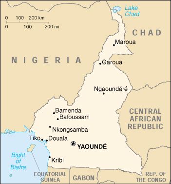
Card: |
|
||
Background: |
The former French Cameroon and part of British Cameroon merged in 1961 to form the present country. Cameroon has generally enjoyed stability, which has permitted the development of agriculture, roads, and railways, as well as a petroleum industry. Despite movement toward democratic reform, political power remains firmly in the hands of an ethnic oligarchy. |
||
Geography |
|||
Location: |
Western Africa, bordering the Bight of Biafra, between Equatorial Guinea and Nigeria |
||
Geographic coordinates: |
6° 00' N, 12° 00' E |
||
Map references: |
Africa |
||
Area: |
total: 475,440 sq km |
||
Coastline: |
402 Km |
||
Maritime claims: |
territorial sea: 50 NM |
||
Climate: |
varies with terrain, from tropical along coast to semiarid and hot in north |
||
Terrain: |
diverse, with coastal plain in southwest, dissected plateau in center, mountains in west, plains in north |
||
Elevation extremes: |
lowest point: Atlantic Ocean 0 m |
||
Natural resources: |
petroleum, bauxite, iron ore, timber, hydropower |
||
Land use: |
arable land: 13% |
||
Geography - note: |
sometimes referred to as the hinge of Africa |
||
People |
|||
Population: |
15,803,220 |
||
Note: |
estimates for this country explicitly take into account the effects of excess mortality due to AIDS; this can result in lower life expectancy, higher infant mortality and death rates, lower population and growth rates, and changes in the distribution of population by age and sex than would otherwise be expected (July 2001 est.) |
||
Nationality: |
noun: Cameroonian(s) |
||
Ethnic groups: |
Cameroon Highlanders 31%, Equatorial Bantu 19%, Kirdi 11%, Fulani 10%, Northwestern Bantu 8%, Eastern Nigritic 7%, other African 13%, non-African less than 1% |
||
Religions: |
indigenous beliefs 40%, Christian 40%, Muslim 20% |
||
Languages: |
24 major African language groups, English (official), French (official) |
||
Government |
|||
Country name: |
conventional long form: Republic of Cameroon |
||
Government type: |
unitary republic; multiparty presidential regime (opposition parties legalized in 1990) |
||
Capital: |
Yaounde |
||
National holiday:: |
Republic Day, 20 May (1972) |
||
Flag description: |
three equal vertical bands of green (hoist side), red, and yellow with a yellow five-pointed star centered in the red band; uses the popular pan-African colors of Ethiopia |
||
Economy |
|||
Economy - overview: |
Because of its oil resources and favorable agricultural conditions, Cameroon has one of the best-endowed primary commodity economies in sub-Saharan Africa. Still, it faces many of the serious problems facing other underdeveloped countries, such as a top-heavy civil service and a generally unfavorable climate for business enterprise. Since 1990, the government has embarked on various IMF and World Bank programs designed to spur business investment, increase efficiency in agriculture, improve trade, and recapitalize the nation's banks. In June 2000, the government completed an IMF-sponsored, three-year structural adjustment program; however, the IMF is pressing for more reforms, including increased budget transparency and privatization. Higher oil prices in 2000 helped to offset the country's lower cocoa export revenues. A rebound in the cocoa market should increase growth to over 5% in 2001. |
||
Electricity - production: |
3.47 billion kWh (1999) |
||
Agriculture - products: |
coffee, cocoa, cotton, rubber, bananas, oilseed, grains, root starches; livestock; timber |
||
Exports: |
$2.1 billion (f.o.b., 2000 est.) |
||
Currency: |
Communaute Financiere Africaine franc (XAF) |
||
Note: |
responsible authority is the Bank of the Central African States |
||
Transportation |
|||
Railways: |
total: 1,104 km |
||
Highways: |
total: 34,300 km |
||
Waterways: |
2,090 km (of decreasing importance) |
||
Ports and harbors:: |
Bonaberi, Douala, Garoua, Kribi, Tiko |
||
Coffee |
|||
Growing-areas: |
in all provinces except in the north Mban, Haute Sanaga |
||
Qualities: |
natural Robusta but also washed Arabica, graded as per beansize and defects |
||
Altitude: |
Robusta: 800/1000 meter |
||
Harvest: |
Robusta: beg. of November to February |
||
Shippingperiod: |
Robusta all the year round |
||
Port of Export: |
Douala |
||
Shipment: |
in container in bags (250 of each 60,- kos net) |
||
Production: |
ca. 1,100,000 bags |
||
Export figures: |
824.232 bags |
||
Caffeine content |
Robusta 2.32 % |
||
Classification |
|||
Classification: |
Methode: |
Beansice: |
Defects: |
Robusta |
|||
Superior |
natural |
gr 0 - 15 def/300 |
|
Extraprima |
natural |
gr 15 - 30 def/300 |
|
Prime |
natural |
gr 30 - 60 def/300 |
|
Standard |
natural |
gr 60 - 120 def/300 |
|
Grade 1 (standard) |
natural |
screen 16/18 |
|
Grade 2 |
natural |
screen 14/16 |
|
Grade 3 |
natural |
screen 10 |
|
Arabica |
|||
A |
natural |
70 % over screen 18 |
|
B |
natural |
70 % over screen 17 |
|
C |
natural |
Perlbeans |
|
D |
natural |
70 % over screen 16 |
|
F |
natural |
70 % over screen 15 |
|